Make a Statement with Waterproof Charts
Discover fresh ways to enhance your life with expertly crafted Waterproof Charts products.
Waterproof Charts 320F Lake
Heart of Abaco Chartlet: Man O'War Cay to Whale Cay (Navigation Chart 12"x 18")
Waterproof Charts 41 Everglades &
Waterproof Charts, Standard Navigation, 11 Champlain Canal & Southern Lake Champlain, Easy-to-Read, Large Print, Waterproof Paper, Tear Resistant, Printed on Two Sides, 2 Charts in 1, NOAA Charts
Waterproof Charts, Standard Navigation, 61 Narragansett and Buzzards Bay, Easy-to-Read, Large Print, Waterproof Paper, Tear Resistant, Printed on Two Sides, 2 Charts in 1, NOAA Charts
Waterproof Charts, Standard Navigation, 56 Cape May to Sandy Hook NJ, Easy-to-Read, Large Print, Waterproof Paper, Tear Resistant, Printed on Two Sides, 2 Charts in 1, NOAA Charts
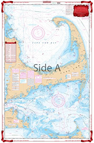
Standard Navigation, 64 Cape Cod and Harbors
Waterproof Charts, Standard Navigation, 102 Cape Small to Boothbay and Tenants Harbor
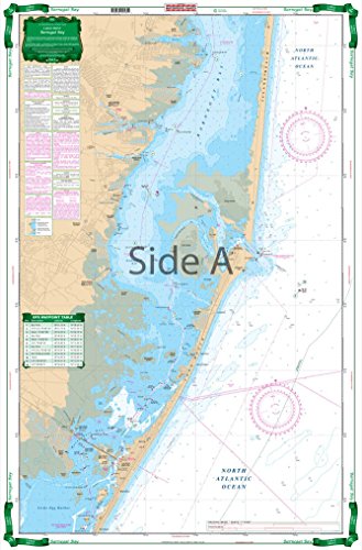
Waterproof Charts, Large Print Barnegat Bay, 56E, Easy-to-Read, Large Print, Waterproof Paper, Tear Resistant, Printed on two sides, 2 charts in 1, NOAA Charts
Waterproof Charts, Large Print, 31E Clearwater Harbor to Egmont Key
Waterproof Charts, Inshore Fishing, 97F Savannah to St. Catherine's Sound
Waterproof Charts, Large Print, 102E Bath to Boothbay Harbor, ME
Waterproof Charts 1F Charlotte
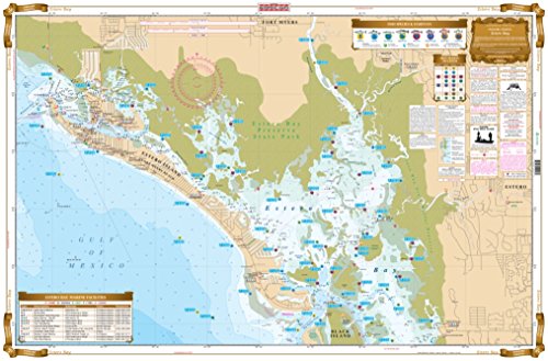
Waterproof Charts 221F Estero Bay
Waterproof Charts 4F Naples Bay
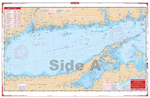
Standard Navigation, 27 Stratford Shoal to Newport Rhode Island
Standard Navigation, 105 Mt. Desert Island Area
Waterproof Charts, Coastal Fishing, 50F Narragansett Bay to Block Island Sound
Waterproof Charts, Standard Navigation, 3 Middle Keys to Sanibel